No-one knew how deep the highest large lake in the Sierra was. So Casey Handmer and Edward Jacobs carried a packraft over Shepherd Pass and found out.
117 mmeasured depth
93 kmwalked, 6 days
4.7 kmpaddled at 12,900′
the mission, in real time ↓
The mission
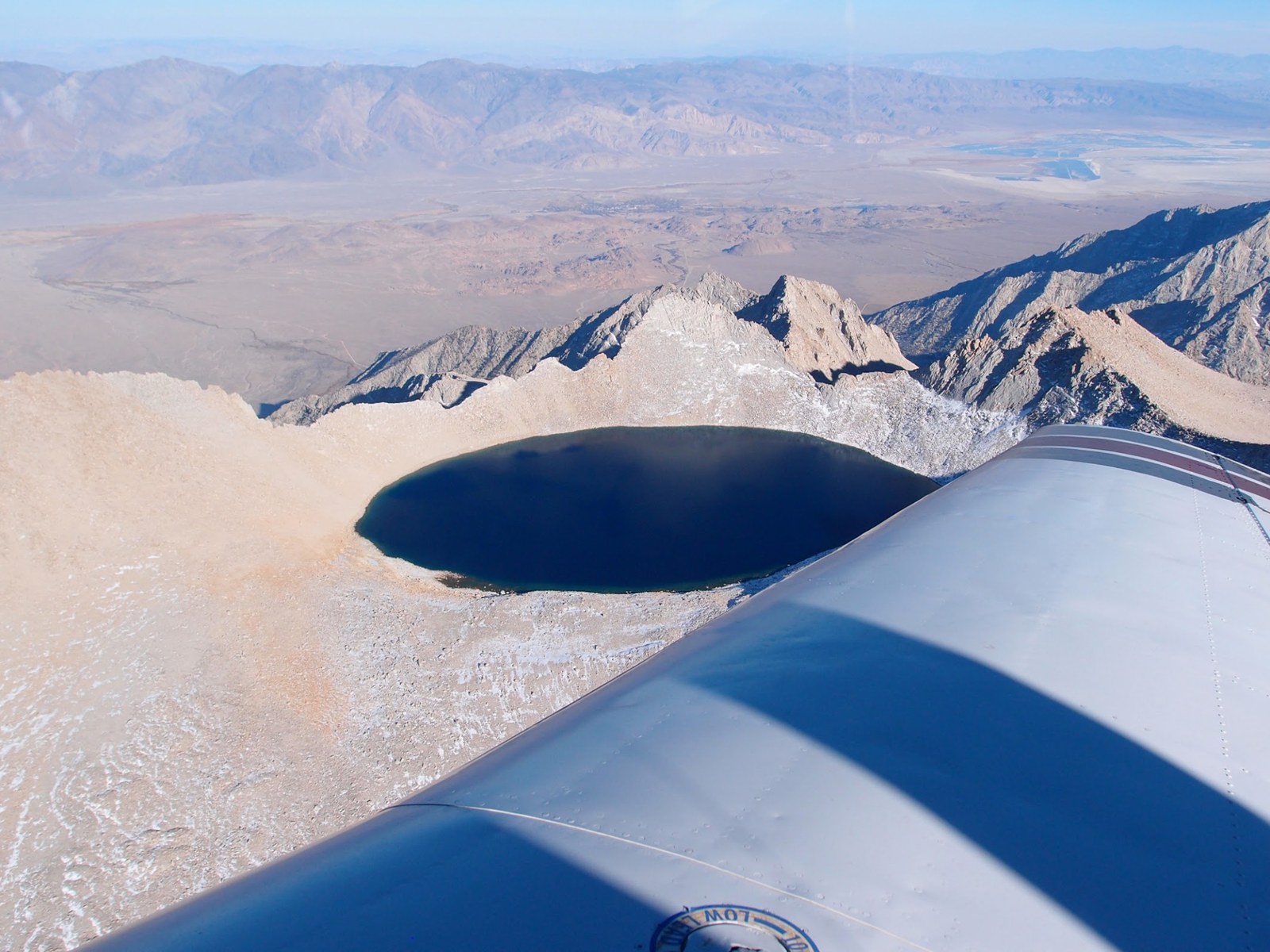
In October 2013, I was a passenger in a private plane exploring the Sierras and saw a peculiar almost rectangular-looking lake, just north of Mt Whitney. I snapped a photo.
October 2013 — the overflight that started itCasey
A few years later, Kim Stanley Robinson told me it must have been Tulainyo Lake, a mysterious lake at extremely high altitude, a favorite of Norman Clyde, and rather hard to get to. He visited it last in 2003.
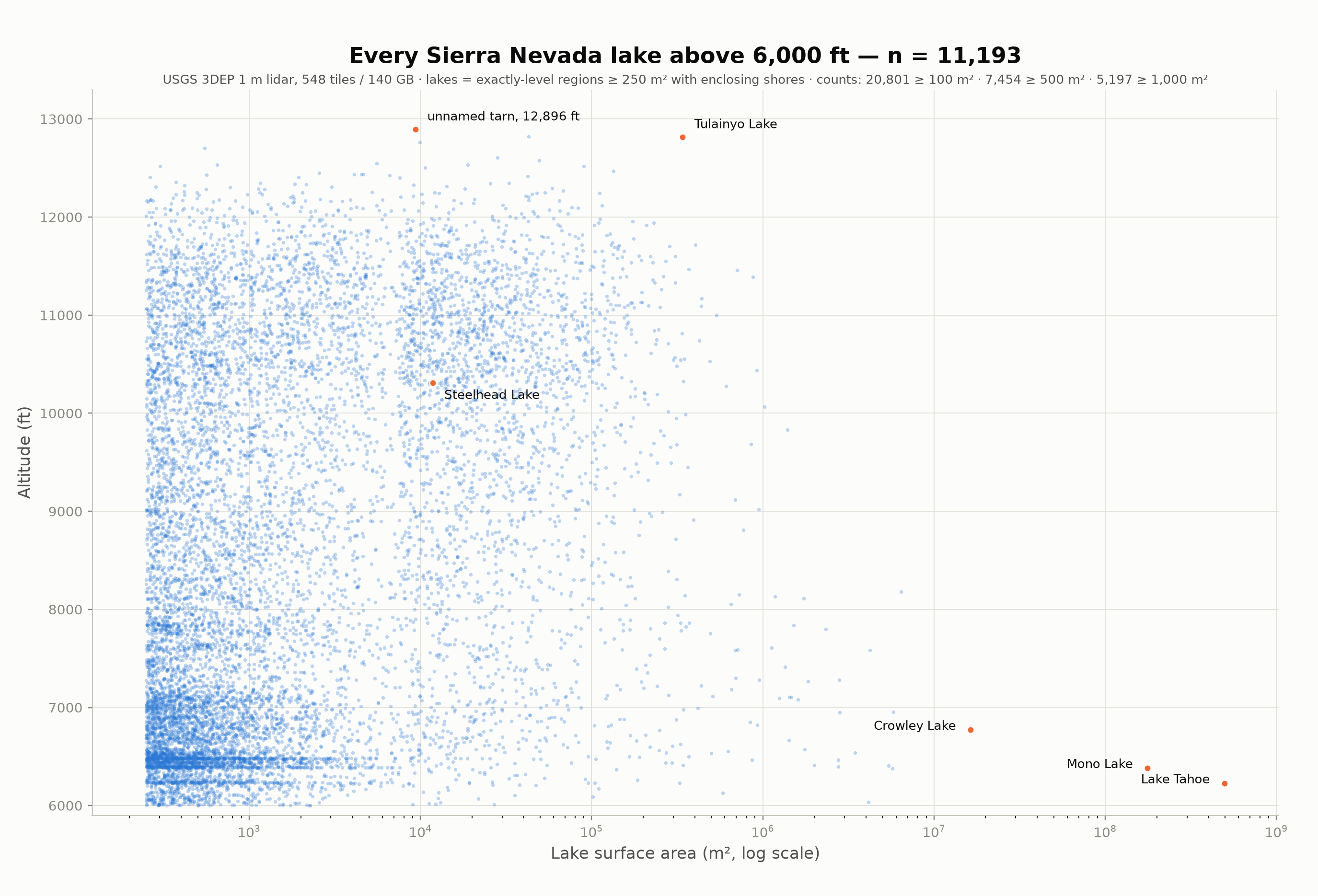
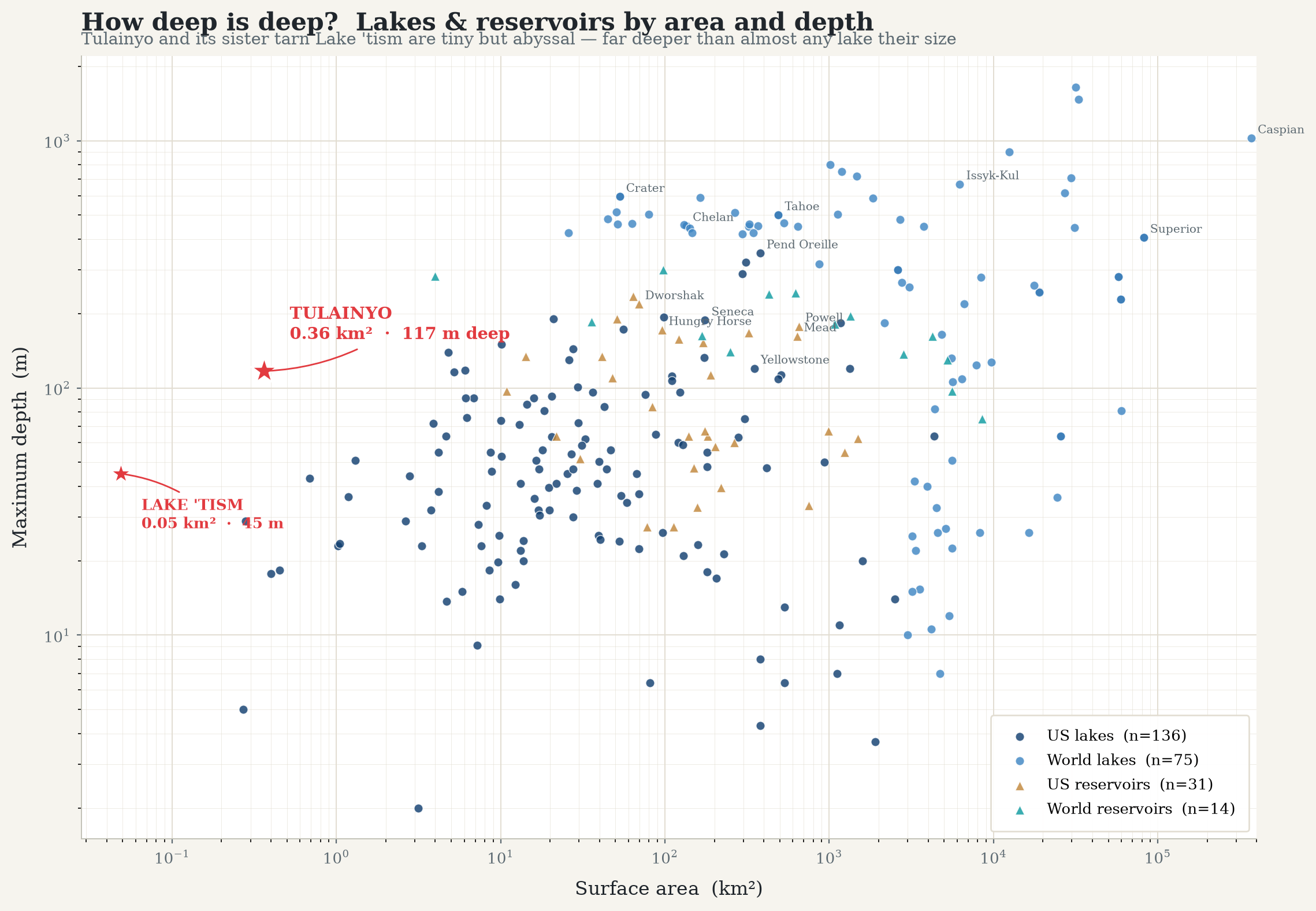
Years later, I ran an analysis on lake size and altitude in the Sierras.
Tulainyo is the one on the top right. Claude made a nicer version of this graph with more modern LIDAR data. Tulainyo basically owns the Pareto frontier of Sierras lakes.
According to the Wikipedia article, no-one knows how deep it is. After last week, I can understand why! I decided I would find out.
Thoreau carefully mapped Walden pond by drilling holes in the ice in winter and plumbing the depths. I would prefer to go in summer! I analyzed USGS data on the surrounding area (back before AI!) and concluded that the lake would likely be between 25 m and 40 m deep, with 35 m being a good median estimate. This would make it about the same depth as Steelhead Lake in the Twenty Lakes basin, which I had sounded last month in a trial run on a separate trip.
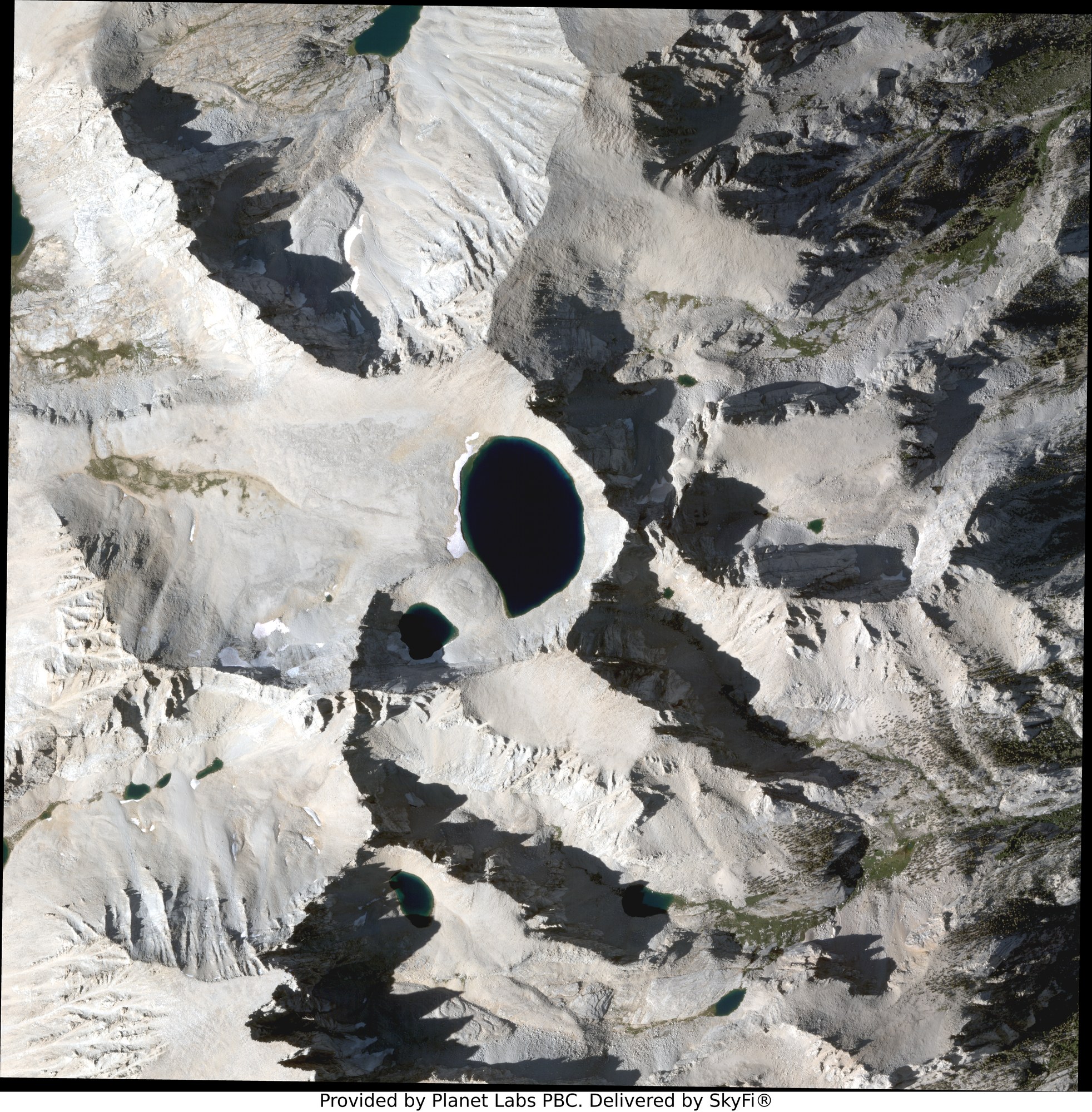
Timing was the main constraint. The lake is only reliably ice free for about six weeks per year, from mid August through September. This is a busy time of year with school starting and various birthdays, so my 2024 and 2025 attempts had to be waved off. In 2026, I locked in dates, obtained permits, and even purchased a satellite image to confirm the lake condition before setting out.
satellite · 31 Aug 2026 The commissioned very-high-resolution image (Planet / SkyFi): Tulainyo (centre) and two nearby tarns are ice free.
Ice free, baby! Let's go!
Route
The closest road to Tulainyo lake is Whitney Portal, a mere 5000 feet below and 2 miles as the crow flies. However, the Whitney zone is loved to death and obtaining permits is nearly impossible. Instead, I planned to access Tulainyo from the north via Shepherd Pass. Even though Tulainyo lake is only two miles from the Whitney Portal parking lot, a climb of 5000 vertical feet would take three nights sleeping above 8000 feet to be useful. And no-one wants Shepherd Pass, so there are always permits available. I got three, because I'm optimistic when it comes to the number of friends I have.
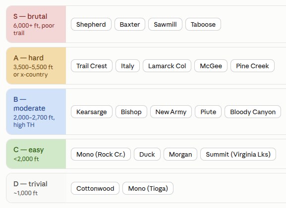
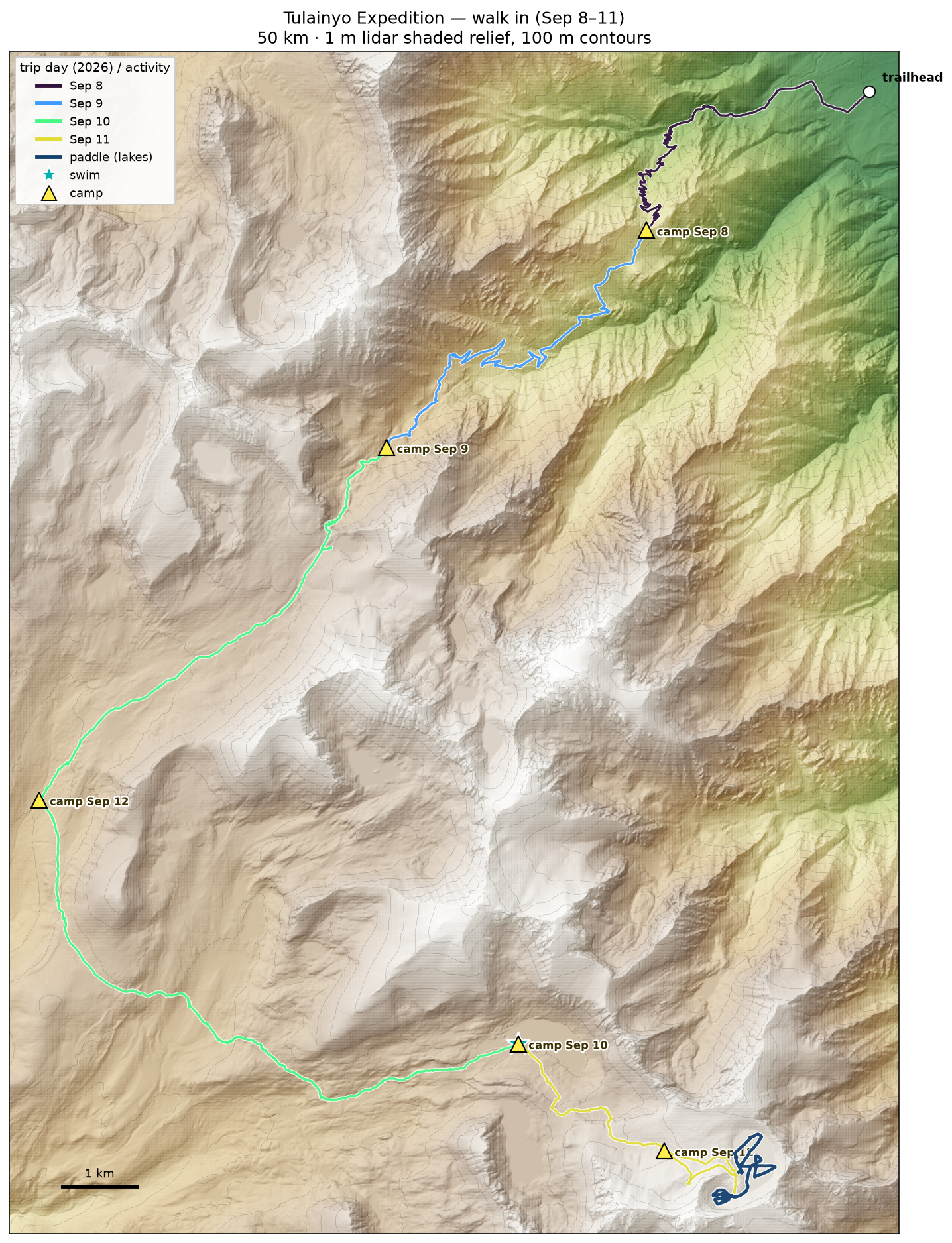
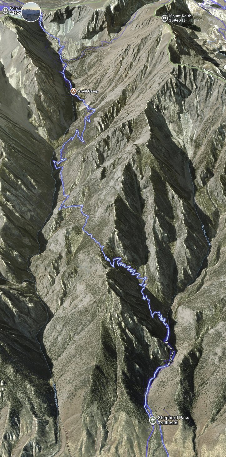
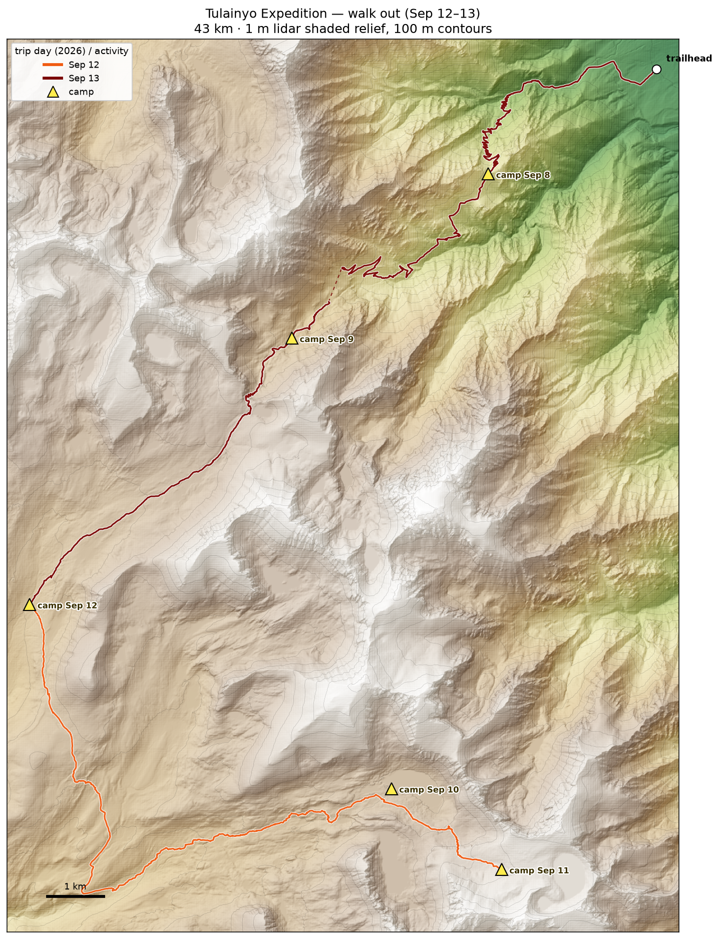
My ranking of the Eastern Sierra passes by difficulty — Shepherd Pass sits in the "S — brutal" tier.route · walk in The approach: Shepherd Pass trailhead over Symmes Saddle, up the Shepherd Creek drainage, over the pass and cross-country to the Tulainyo basin. Camps marked; the paddle traces both lakes.Shepherd Pass · the approach The same approach in 3D (Strava): from the trailhead up the Symmes Creek switchbacks, over Symmes Saddle into the Shepherd Creek drainage, past Anvil Camp and on toward the pass. This lower half is the hot, exposed grind we did at night.
Introducing my brave companion
Permits in hand, I reached out to a bunch of climbing and adventuring partners. Most of them, recognizing a terrible idea, begged that they were busy but to call them for the next one. (Ha ha! My next target is even worse!!)
Edward Jacobs answered the call. Leading Starship production ops at Starbase is such a chill job he couldn't claim to be busy, but it apparently has given him a deep well of suffering ability. And, it transpired during the hike, this was to be his first ever camping trip - a baptism of fire!
A note on fitness
Since getting my ass handed to me on a traverse in the Alps in 2024, I've been intermittently engaging in actual deliberate exercise, with disturbingly positive results. My latest routine is rucking a 40-50 lb pack up my local trail after dark, 2 miles and 1000′ each way. Descent loaded is essential for strength and coordination, and hiking in the dark helps me avoid sun, people, and overuse of visual aids in walking. Fitness for a trip like this encompasses strength and conditioning, but also cultivating some mental toughness.
I attempted Rainier earlier this year and found that chill strolls up my socal mountain trail had not prepared me well enough for enjoying the intense wind and snow of high altitude mountains. It didn't make a huge difference in the end. In contrast, on this trip to the Sierras I even enjoyed a storm dropping hail on my face - because I've seen it before and it's better than answering emails.
This is a radical concept, but in order to carry heavy loads on mountains I prefer to train by carrying heavy loads on mountains. The general goal is 40 lbs uphill 1000′ in less than 60 minutes, and at peak condition I was doing 50 lbs in 45 minutes. It is totally possible to enjoy exploring the Sierras, particularly on more maintained trails, without this level of physical strength, but I would strongly caution against attempting a trip to Tulainyo lake while carrying a pack raft and other stuff without serious fitness work first! I suffered no blisters, pack harness wounds, or unexpected losses of footing.
Gear
I knew Shepherd Pass was non-trivial, but I didn't appreciate that it's among the harder passes in the Eastern Sierra. More than 6000 feet of ascent, along with a fun 500′ jog in the middle where you get to descend and then re-ascend. Also, no water between 7000′ and 8800′, including the 9000′→8500′ jog. In any case, I didn't want to take anything I didn't absolutely need.
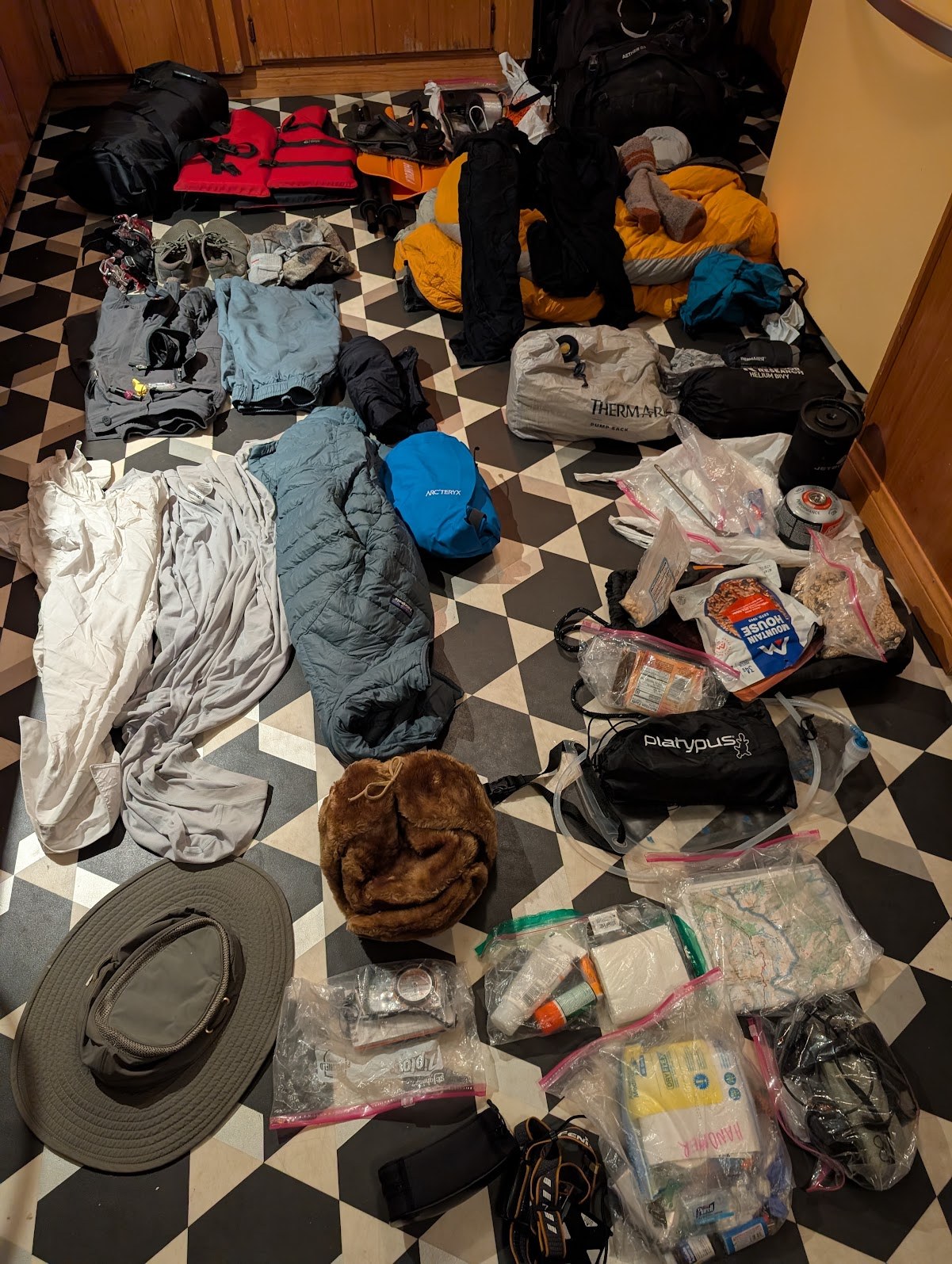
everything, laid out after the returnCasey
Photo of all the gear after I returned, including un-eaten food (enough for two more days without rationing).
Shoes (Merrell Trail Glove 6, at home in the boardroom or on a horrific mountain), socks (3 pairs); hat, sunglasses (spectacular reds in the high country)
Note the exclusions. Boots? Gaiters? Tent? What rubbish! Decadent nonsense! Edward needed only the marginal stuff to support him. Clothing, shelter, food. We initially targeted a dry pack weight of 12 lbs but weight at the car was (I think) almost 40 lbs.
Tuesday
September 8
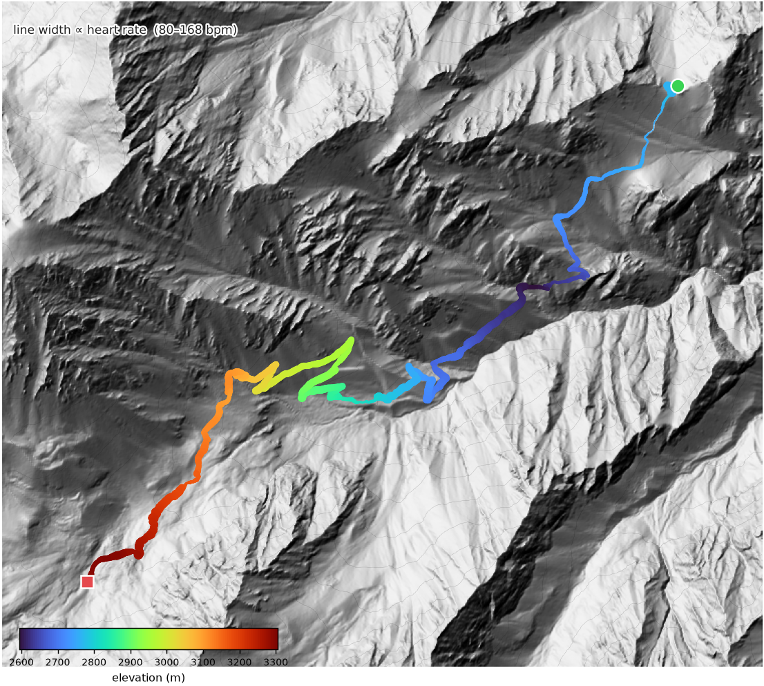
▲ 951 m→ 8.6 kmBurbank → Symmes Saddle
Edward arrived at my place Monday afternoon and was immediately attacked viciously by the wild animals my wife and I have generated and allow to populate our house, otherwise known as my children. We did a quick gear check, eliminated duplicated stuff, and I suggested he sleep on the living room floor with his new inflatable mat and sleeping bag - better to test them here than in the mountains!
Tuesday, we went to Terraform for a few hours, then in the early afternoon headed north via the Muroc test site in Rosamond. We enjoyed not having to carry 2000 calories by eating an ambitious dinner at the Mt Whitney Diner in Lone Pine, then set out to find the trailhead via Independence. At sunset, a bad washout defeated the offroading capabilities of my venerable Model 3, so we parked and hiked the extra mile to the trailhead enjoyed by real hikers with real SUVs. Our "hack" to avoid the pitiless heat and exposure of the first half of Shepherd Pass was to do it at night, which worked very well. A handful of trail-following difficulties were offset by the supreme convenience of being largely unable to see the challenging exposure of a handful of places where the trail got very close to an edge. We saw them five days later on the way back down, by which time someone had thoughtfully covered the wrong turns we made with branches.
The trail follows Symmes creek valley until it becomes too steep, then crosses Symmes saddle into Shepherd creek, which is more navigable above 8500′ (below is too steep). An ingenious and nefarious route finding solution.
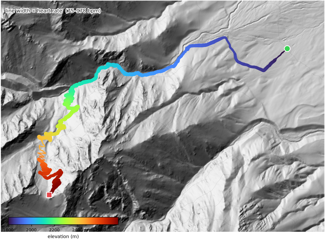
The portion up to Symmes saddle has about 50 switchbacks, which we broke into sublists of shorter and longer ones, then ticked off with grim determination. Fatigue dulled pain and I enjoyed an intense 4 hour cardio workout. When we pulled into Symmes saddle around midnight I suggested we hit the sack and continue in the morning, which was a good choice in retrospect. We had enough water but stumbling would have been inconvenient.
telemetry · Sep 8 The night approach on shaded relief — the line is coloured by elevation, its width proportional to heart rate. 8.6 km, +951 m to Symmes Saddle.
Wednesday
September 9
▲ 734 m→ 9.5 kmto The Pothole, 11,200′
Up at first light, Orion lit up the eastern sky and pointed our way up the valley. Over the course of the week, Orion always greeted us on waking and pointed the way to our destination - conveniently it is a very pointy constellation and points in many directions.
We moved down the trail, found water flowing at 8800′ on the re-ascent, continued past Mahogany Flat, and into Anvil Camp. We took breaks every 500′ or so, making it to The Pothole at 11,200′ in the early afternoon. Each time we started up I stared with disbelief at my grotesquely distended pack, which eventually took on the character of an extremely insistent and demanding lover. Rain/storms were forecast and we decided not to continue into thinner air and more exposure and instead put our feet up, drink water, and wait for our bone marrow to make more red blood cells. The weather came from the west which was obscured behind the escarpment but I enjoyed lying on the ground and watching the clouds boil over the rim. Eventually the rain did start but this trip I brought rain pants and a jacket (expecting to need to continue hiking through bad weather) and just soaked it up. Edward began to suspect I was a lunatic. I began to converse with my food options. Conveniently, the storm broke with hail and heavy rain *right* as I served dinner, but by 7:30 pm it had dried up and I was able to sleep once more with the bivvy bag open watching satellites and shooting stars.
telemetry · Sep 9 Down from Symmes saddle, then the long grind up to The Pothole.
Thursday
September 10
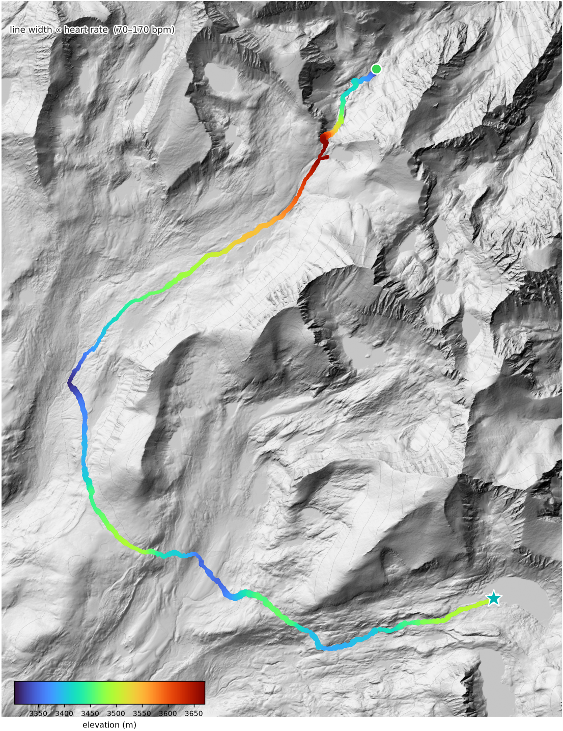
▲ 806 m→ 19.5 kmover the pass to Wallace Lake
By now we were about a day behind my notional schedule, but it hardly mattered. We had plenty of time and too much food. We bundled our wet stuff and trundled upwards towards the pass. The trail took us over about a mile of rough moraine and then up to the loose headwall, the original trail painstaking installed about a century ago still holding up quite well. Huge blocks fitted into place. I'm not certain of the history but it was probably a depression-era works project, supported by burros and infinite rice and beans. Many of these trails were designed for stock rather than hikers with nylon! We set an aggressively stately pace (perhaps 80 small steps and 10′ of vertical per minute) and before long were up to the rim, where the relatively flat alpine plateau greeted us with endless vistas towards the western divide. Right at the pass is a lake where we topped off our water supply and enjoyed breakfast while drying some things. Strategically, it's best not to eat heavily before intense cardio/altitude work and best to start off slow and increase pace as able, rather than to dip into anaerobic capacity within a minute of starting and spend the rest of the day winded.
After packing nearly all our gear we cruised down the trail towards the JMT, passing a few hikers on the way. Most of the Shepherd Pass hikers are climbing Mt Tyndall and/or Mt Williamson, two 14ers in the area. There are half a dozen equally lovely peaks between 13,900′ and 14,000′, but they get no love. The JMT itself is below the treeline but gradually climbs back onto a high plateau that separates the Wright Lakes basin from the Tyndall basin. Facing the prospect of an 800′ descent followed by a 1000′ ascent back to Wallace lake, we opted to cut the corner and traveled cross country over the foot of Mt Barnard (at 13,997′ feet so close to glory) into the Wallace Lake basin. Our bearing lined up perfectly with the north flank of Mt Whitney, which looks great from any angle. This route required some route finding and rock hopping, and at some point it looked like we would get rain and storms again, but the major downpours split around us to the north and south and we barely got sprinkled on. Descending into the Wallace drainage we expected to find the trail but there was barely anything, so we traced its course up to Wallace lake and dropped our packs. I was sweaty and hot and took the opportunity to have a crisp swim. Edward mostly questioned his life choices but we had a good dinner. Once again, I slept in the open (tents are an unspeakable luxury) on my trusty sleeping mat. Edward found his enormous bear canister too small to contain his heaviest food items, which were enjoyed by a rodent in the night.
telemetry · Sep 10 Over Shepherd Pass and cross-country to Wallace Lake. The ★ marks the crisp swim — logged with no GPS, placed here at the lake surface.
This trip I had decided to treat myself by upgrading to the most advanced sunscreen I could find, an altitude rated, sweat proof, water proof, sun proof, 50+ SPF concoction of Nobel Prize-worthy chemistry and frankly deceptive labeling that ran in torrents into my eyes and mouth. I didn't get burned but I'm going back to the trusty Banana Boat 30 SPF sport, with about 10 layers interleaved with dust and tears.
Lying in a snuggly sleeping bag listening to the hum of my kidneys processing high altitude (you will have to get up as soon as you're comfortable!) and watching the stars pop out, we saw the space station flare overhead. As civil twilight turned to nautical twilight and astronomical twilight the stars intensified. The Sierras are not the darkest skies in California but I estimate we could see down to 6.5 mag, with the Milky Way tangible. Satellites are visible as the sun's rays leave the atmosphere but still touch LEO. They begin to vanish into the Earth's shadow in the east just as the western sky is getting truly dark, then looking anywhere one's peripheral vision swarms with barely-visible satellites, perhaps 50 or 100 just barely visible at any one time, and rarely without averted vision. Then the wind dies down, the stars blaze in their slow rotation around Polaris, and the patient camper is rewarded with shooting stars every minute or so, more in the early morning. The alpine sky alone is worth the effort.
Friday · summit day
September 11
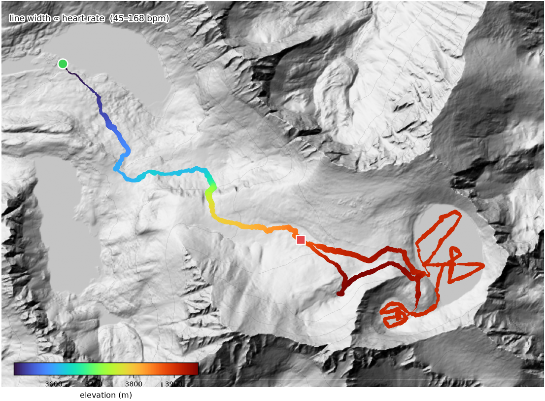
▲ 533 m→ 12.0 kmTulainyo — bathymetry
I woke up with a lot of dew on me and my stuff. It hadn't rained but perhaps the humidity had decided to find the ground anyway. I left everything out in the wind as the sun rose, assuming that at least some would evaporate before I packed. It did, and in so doing dissipated heat, freezing the remaining water in sheets to my stuff. I shook it vigorously and it snowed!
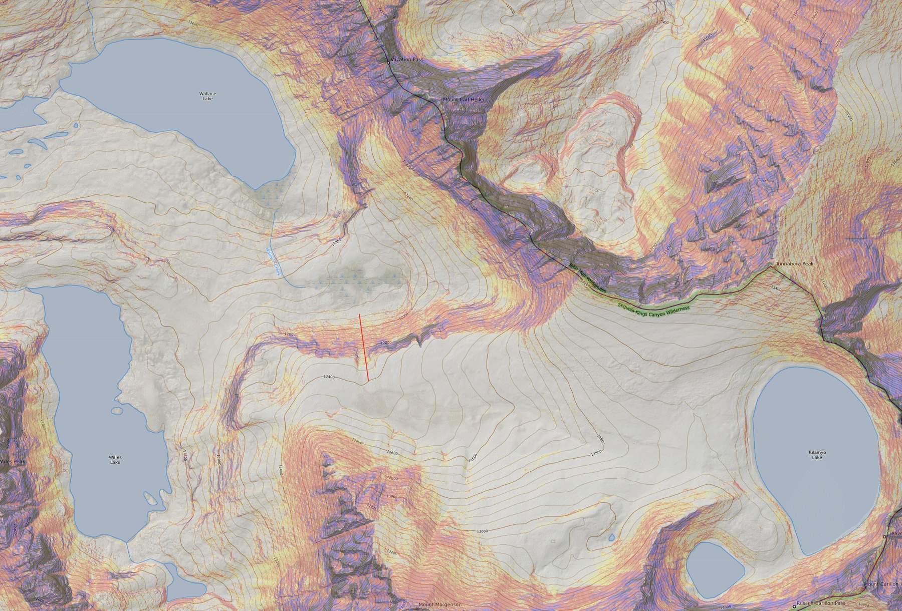
We were camped at Wallace Lake at about 11,400′. Our route took us east, up a 500′ chute filled with enormous boulders on the verge of sliding, and then east again up the Tulainyo basin, a great example of a glacial hanging valley.
I've marked the chute here with a red line. The Sierras are a relatively young mountain range and have hundreds of high glacial basins, many of which are connected by traversable "passes" in a fun meta-maze. You can often walk for days between objectives without encountering any other people or trails.
the chute The red line marks the ~500′ boulder chute from Wallace Lake up into the Tulainyo hanging basin (Tulainyo Lake, right).
I christened this chute the "super trivial staircase" as Edward called it the worst experience of his entire life, experienced involuntarily for the second time as an alternative to living at Tulainyo Lake for the rest of his life. It was a second class scramble complicated by heavy packs and a desire to not die.
Once on top, we followed the creek upwards through another lush, beautiful meadow. Tulainyo drains underground (roughly 100′ of loose rock above) and eventually we found the highest spring with collectible water gushing out of the ground. Nearby we found an area with relatively flat ground, cleared out space for two sleeping areas, secured wet objects under rocks to dry in the sun, and rested.
After lunch, I gathered the boating things (a disconcertingly large fraction of my pack volume) and we ground up the hill towards the saddle that obscured the lake. Within a few minutes we crested the rise and the whole magnificent abomination came into view.
It was quite windy and I wasn't sure how well the boat would track. But this time I had brought the other half of the paddle and the skeg, so I got to work.
I slapped on my rain jacket and pants (a wise choice in retrospect), jumped in, and started collecting data. Almost immediately the sonar buoy faulted out so I spent a few minutes debugging it. My phone in a waterproof case around my neck guided my exploration and direction and I proceeded to battle upwind to the north. I then zigzagged back and forth. I was struck by two observations. First, the bottom was uniform and entirely consistent with a null hypothesis - there was no discernable underwater structure or ridges. Just a nice conical hole. Second, it was deep! My prior estimate was that the deepest point of the lake might be 35 m. On my first transect, across the north end of the lake, I maxed out at about 65 m. I began to worry that the sonar buoy's 100 m depth limit might not be adequate.
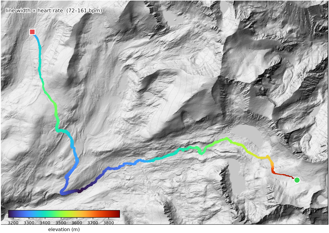
telemetry · Sep 11 The summit day. Elevation-coloured, width ∝ heart rate — the line thins to a fine trace as the walking becomes paddling on both lakes (bottom right), where the heart rate falls.
I continued my zigzagging for about an hour, having a terrific time. No sensation of being winded or exhausted, the boat moved reliably at about half a swift walking pace in any direction, it rode the waves and kept me alive. Obviously falling in would be Really Bad, especially far from the edge. The temperature was 9 C, too cold to swim in for any length of time.
As it happened, there was a region about 200 m across in the middle where the sonar buoy maxed out. So I don't know exactly how deep the lake is, but I can use math to emplace some fairly strong bounds and a good reconstruction. I welcome further effort in this direction. I did take the opportunity to sample 3 separate transects of the "hole" to ensure I had plenty of data for this effort.
While we were up there, I wanted to check out the unnamed lake immediately to the south west of Tulainyo. For the purposes of this discussion and in honor of the impulse that had driven us up there in the first place (and which drives my detailed simulation of a terraformed Mars' entire planetary hydrology) we employed the working title "Lake 'tism".
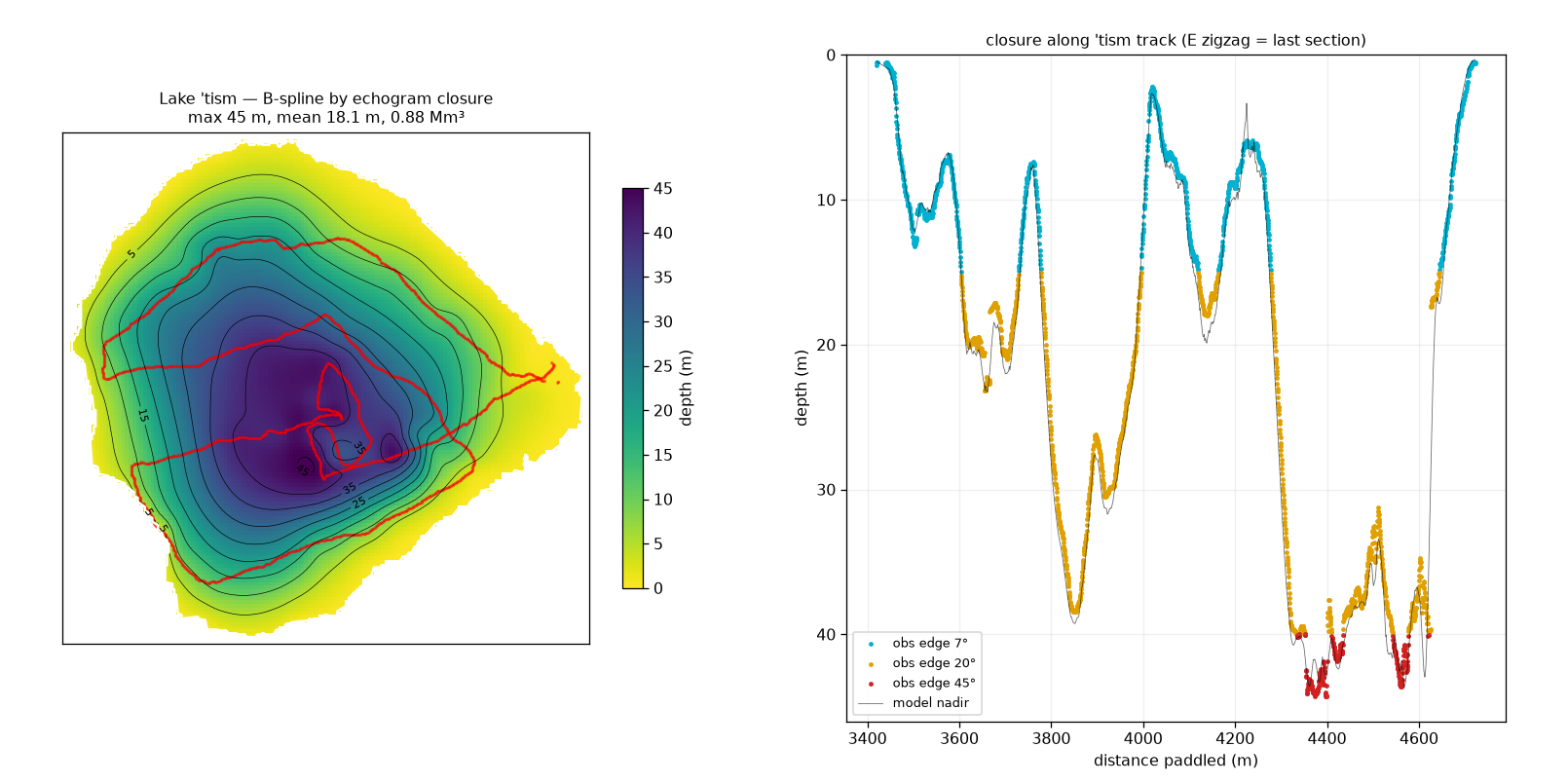
By this point the sun was setting behind Mt Russell so the lake was partly shaded. I portaged the pack raft over the gap and jumped in, adopting a Hilbert space filling curve to sample the coast and central parts of the lake. Again, I was shocked at its depth. Here was a tiny lake, barely larger than a swimming pool, with a maximum depth of 45 m! That's far deeper than Sydney Harbour, where I learned to sail, and which is regarded as one of the finest natural harbors in the world.
After about 20 minutes I had collected the necessary data. With a bittersweet feeling I realized in just two hours we'd accomplished our mission and my alpine boating adventures were over for the foreseeable future. I drained the raft, deflated it, and packed it back into its container. Will it ever see another adventure?
After collecting my stuff from the launching spot, we traversed at 13,000′ around the north flank of Mt Russell to a third and far smaller lake (or tarn) which I suspected might be there. We confirmed its existence, though visually its depth is no more than 6′. Still, at 12,975′ or so it is one of the highest ponds in the entire mountain range.
We returned to our high camp, ate a meal of sweet victory, gave thanks for not drowning, and prepared for a cold and windy night. My sleeping mat transformed into a self-deflating one and I slept poorly. But not before I'd screenshotted the key data and texted it to the outside world. My phone might not make it back but the data must survive.
Altitude was taking its toll and we decided not to summit the surrounding peaks and instead head back towards Shepherd Pass, with a stretch goal to reach Anvil Camp that afternoon. We were up at first light about an hour before dawn, swiftly packed, and headed back down the basin. Descending into thicker air is a rare pleasure, we moved quickly enough that my ears popped more than once. We hit the super trivial staircase at sunrise and found that the route on top of the western-most waterfall was more secure. Somehow the blocks, while slightly steeper, were more locked in. Without any backtracking we found a way to the bottom where we greeted the sun and reduced wind with glee. At the outflow of Wallace Lake we picked up the paleo-trail and headed west. Unfortunately, the trail frequently disappeared or moved towards extremely difficult terrain so we once again resorted to route finding, which worked well enough albeit slowly. Where it actually existed, the trail rarely coincided with the mapped unmaintained trail. But following Wallace creek on the north side eventually delivered us to the JMT where we rested and snacked before grinding back up about 1000′ towards where we had departed a few days before. By the time we reached the Shepherd Pass junction we were pretty cooked and the day was getting late. I didn't want to push up to the pass only to get stuck at 12,000′ with no shelter if we ran out of daylight. Instead, we set up camp by the creek and attempted to demolish our remaining food, with some success.
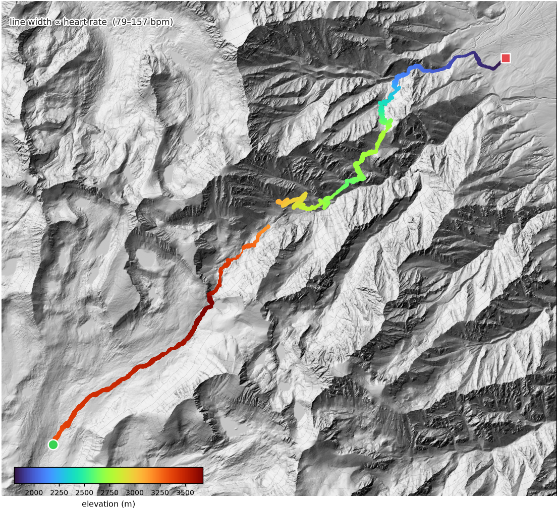
route · walk out The return — down out of the basin, back over the JMT and up toward Shepherd Pass, then out. The shared trail appears once here (it was drawn on the walk-in map for the approach).
This camp site, like other areas within the tree zone, was badly affected by sick and poorly maintained trees. I understand why the National Parks strongly discourage camp fires above 10,000 feet. Biomass accumulates very slowly at these altitudes and fires can easily spread. On the other hand, even in this camp, multiple trails were degraded because of fallen limbs that anyone with a folding saw could dispatch in five minutes if they could throw them on a crackling fire, and many of the trees had sagging lower branches touching the ground, which guarantees that a ground fire will leap into the crown and kill the tree. I suggest that National Parks adopt a licensing scheme where regular hikers complete an online course and create a modest forcing function for the reduction of fuel and maintenance of forests in heavily trafficked areas.
telemetry · Sep 12 Basin to Tyndall Creek camp. 17.5 km of mostly downhill.
Sunday
September 13
▲ 539 m→ 24.8 kmout to the car
Edward woke me, as agreed, at 3:30 am and ready to go. For the first time in days I'd had a solid sleep and weird dreams. Now I was on the spot to get packed and ready ASAP. It took 19 minutes. We headed up the trail, which was visible enough under starlight that it was possible to walk without a light. It felt like floating through space with distant mountains visible only as dark shapes eclipsing the star field.
We got to the pass and found Edward's cup which he'd left there a few days before. It was cold and very windy, but as first light found us we carefully descended the switchbacks and found our way to the Pothole and Anvil Camp, where we had a cheerful and well-deserved breakfast of hot oatmeal and copious sugar. The rest of the route passed without incident, the last few hours in daylight and thus allowing us to see what we'd missed on the way in. Descending under load necessitates extreme smoothness to minimize impacts!
Back at the car we enjoyed our victory soda and blasted south in time for dinner. The previous day, Edward expressed his disbelief that I'd talked him into such extreme levels of masochism and his desire to be separated from his camping gear forever. Yet, as the 395 carried us south I caught him staring transfixed at the skyline. I suspect we will be back.
telemetry · Sep 13 The 24.8 km walk-out, 3:30 am alpine start to victory soda.
Data analysis
We begin with a USGS DEM of the area, a commissioned high resolution recent satellite photograph, the sonar buoy's raw data (including GPS location and time, ping reflections, water temperature, and so on), plus a trace from my Garmin watch.
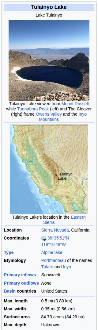
the premise Wikipedia, going in: max depth Unknown. Here is where we fix that.
First up, the datum. The lakes were about 6′ deeper than the USGS chart indicated — their levels can fluctuate somewhat over time. Their current (2026) level is about 3909 m. All depths below are referenced to that 2026 surface, not the older DEM datum.
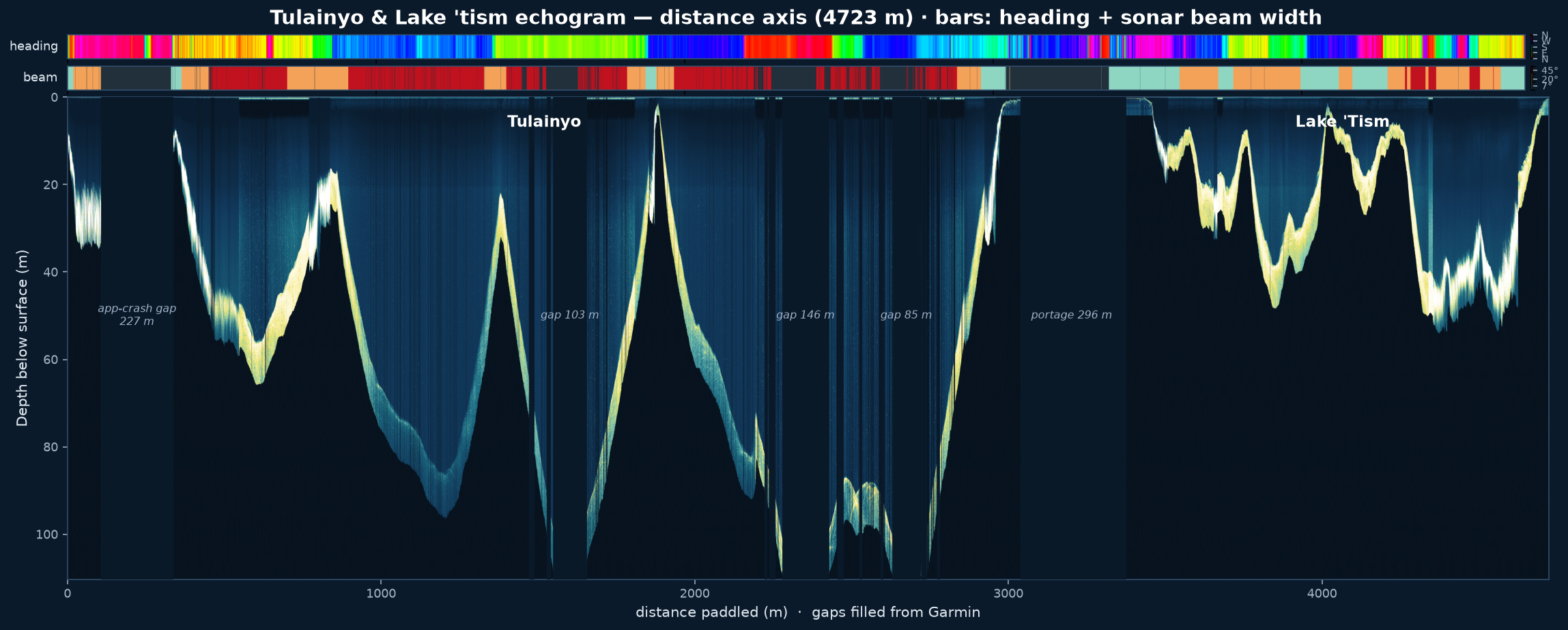
Once various infelicities in the sonar dataset had been ironed out, we were left with the following echogram. This shows I paddled just over 4 km, and that the lake floor gradient is astonishingly uniform even at 100 m. There is very little sedimentation in this lake.
echogram Every sonar return along the 4.7 km paddled, with heading and beam-width bars. The bottom vanishes past ~100 m on the deepest passes — the lake exceeds the buoy's range.
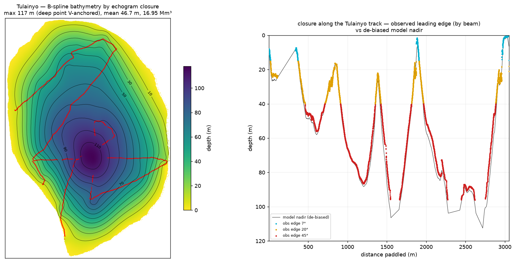
To reconstruct a bathymetric model, we begin with a prior that assumes each depth ping measures depth directly downwards. However, the walls of the lake are steep enough that this is not true in general, and depending on the beam width in use, it's actually quite different. So the prior is updated by generating a synthetic dataset based on the geo-referenced position of every ping, which is then compared to the actual data. The bathymetric parametric model is adjusted and iterated until there is good agreement. This means that the data we collected could actually be generated by a lake with this bathymetric shape. More details in the methods section.
The raw soundings, the analysis code and every reconstructed grid behind these figures are open data — released under CC BY 4.0, with download links in the methods below.
Tulainyo · reconstruction Left: the reconstructed floor, 10 m contours. Right: the concordance of synthetic and actual sonar (de-biased model nadir vs observed leading edge). The lake is astonishingly deep. I do not know for sure if it is 117 m deep, but I can state with certainty that at 100 m the trend was smooth, and I took three separate transects of the "hole". Still, if I was going to hide an alien space craft in a high altitude lake, that would be a good place.
sonar shots · shallow→deep ■ the 80–100 m limit band
drag rotate · shift/right-drag pan · scroll / pinch zoom
the lakes in 3D Both reconstructed floors — Tulainyo and, to its south-west, little Lake 'tism — in their true relative positions, rotatable, with every one of the ~3,500 sonar shots drawn as a ray from the buoy on the surface down to the point it sounded. Over Tulainyo the rays bottom out around 100 m (gold marks the 80–100 m band) — where the buoy loses the bottom over the deep hole — while the reconstructed floor plunges on to the 117 m apex the sonar never reaches. True scale, no vertical exaggeration. Drag to spin it; scroll or pinch to zoom.
In short: the sonar gives hard depths down to ~100 m; the last ~15 m to the 117 m apex is inferred, and a beam-geometry check shows the flattening at the very bottom is the sonar's own cone, not sediment — so the basin really is a near-empty 117 m V. The next three figures walk through that argument.
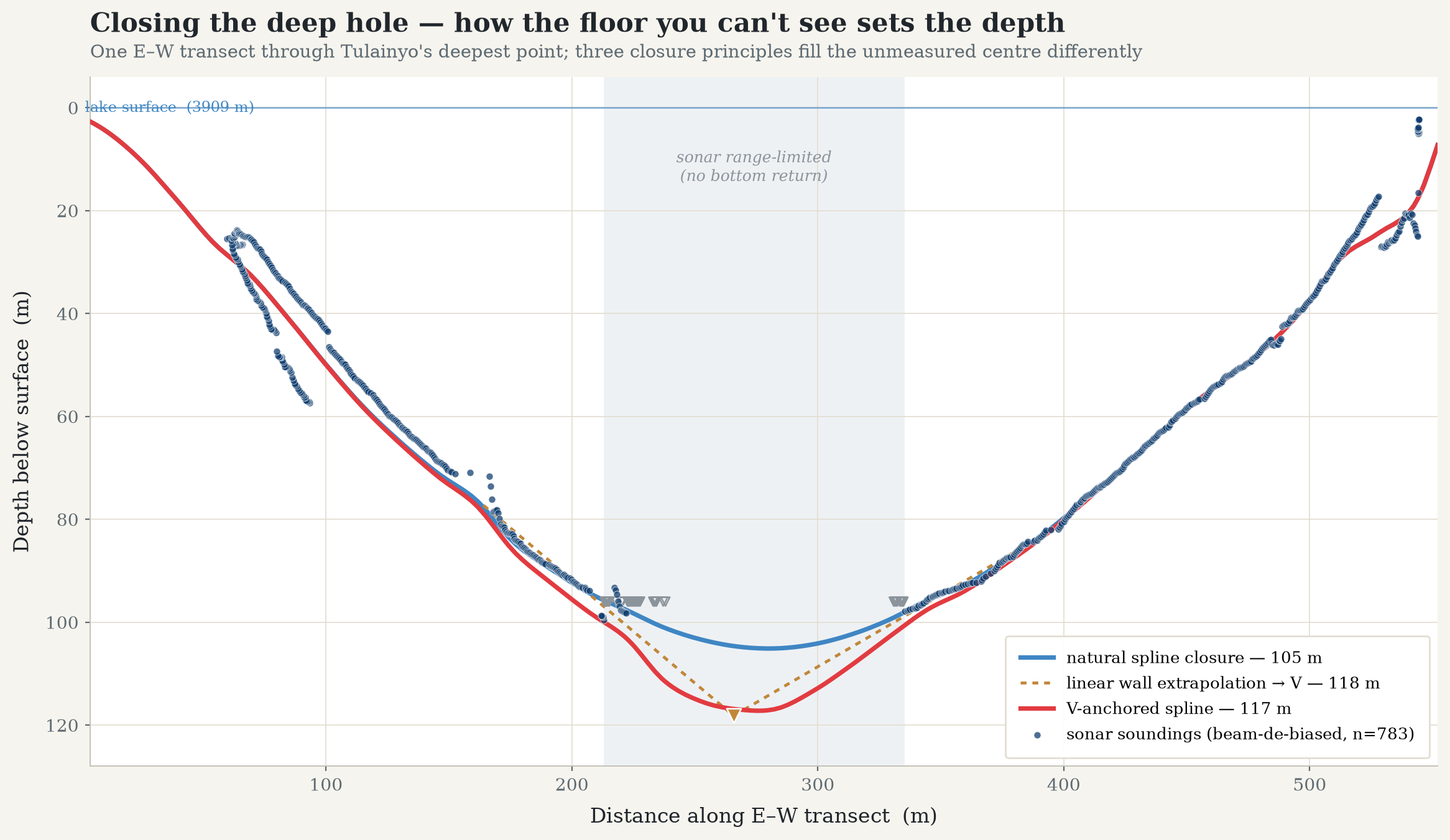
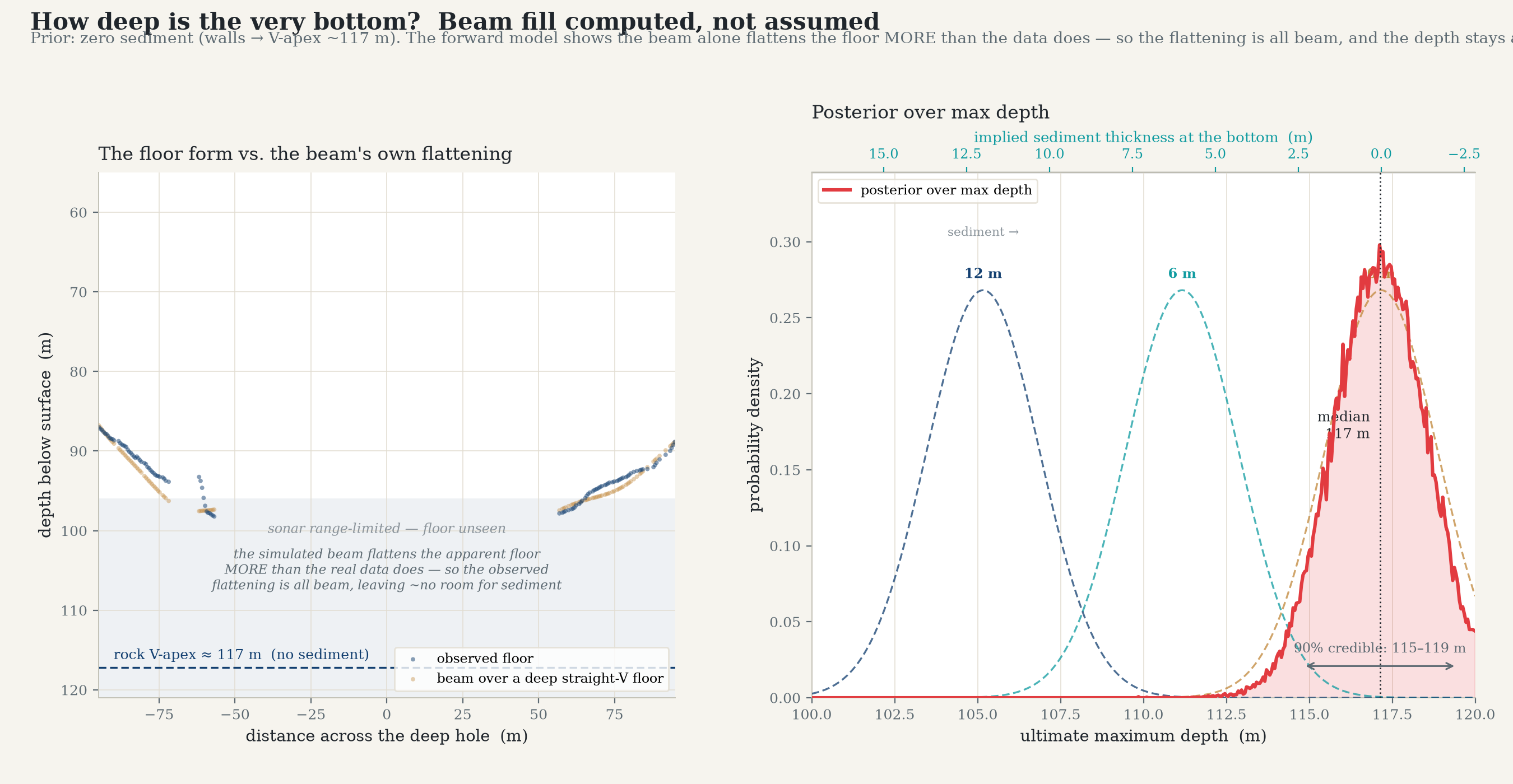
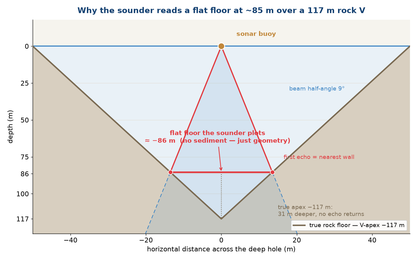
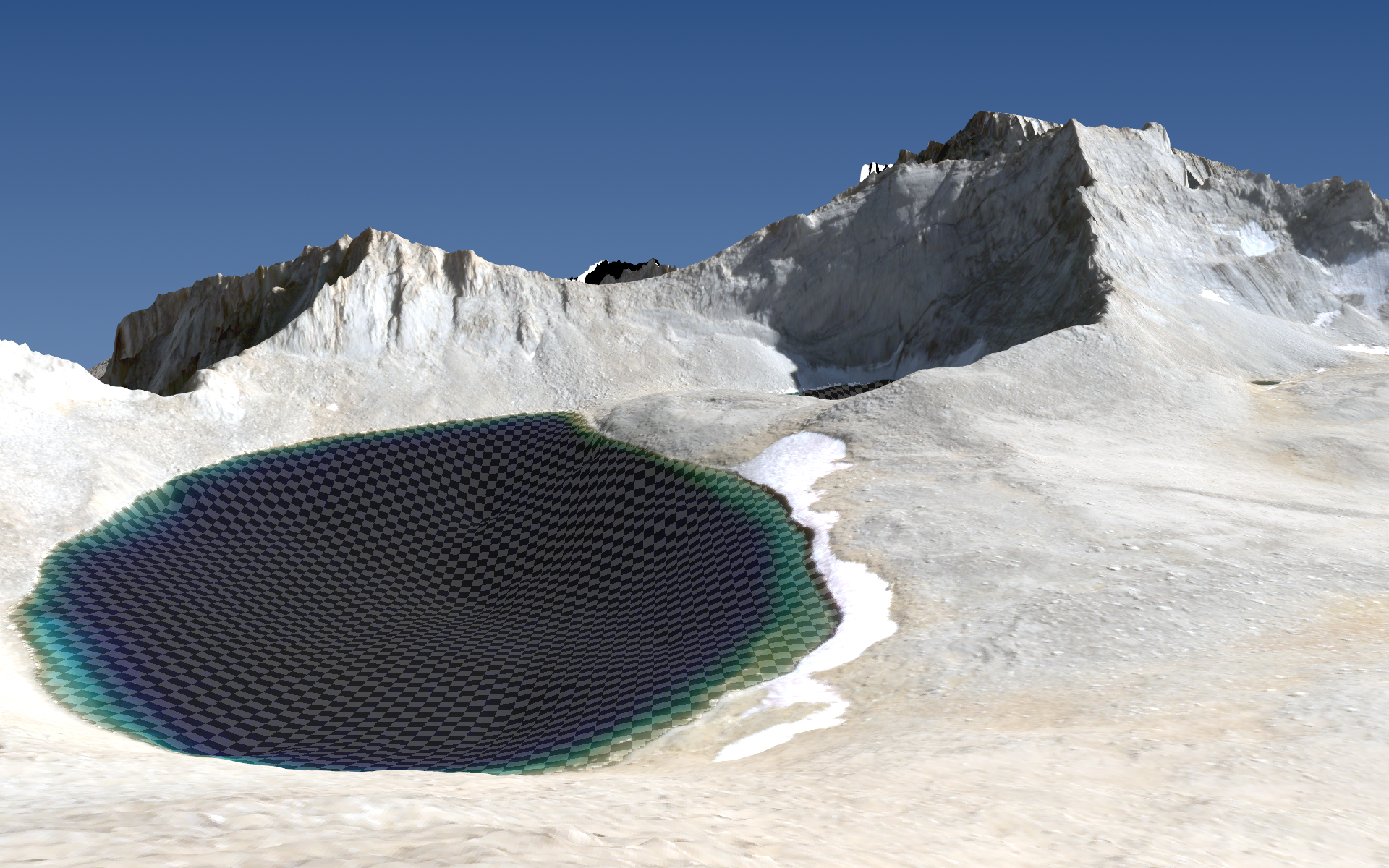
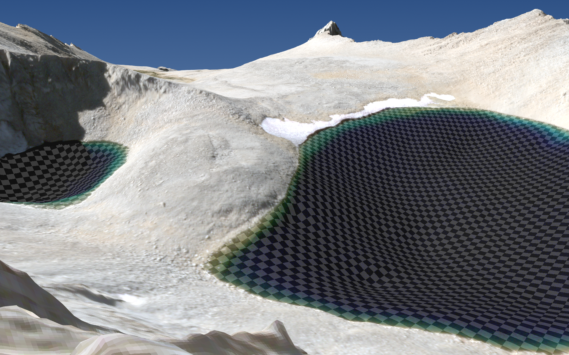
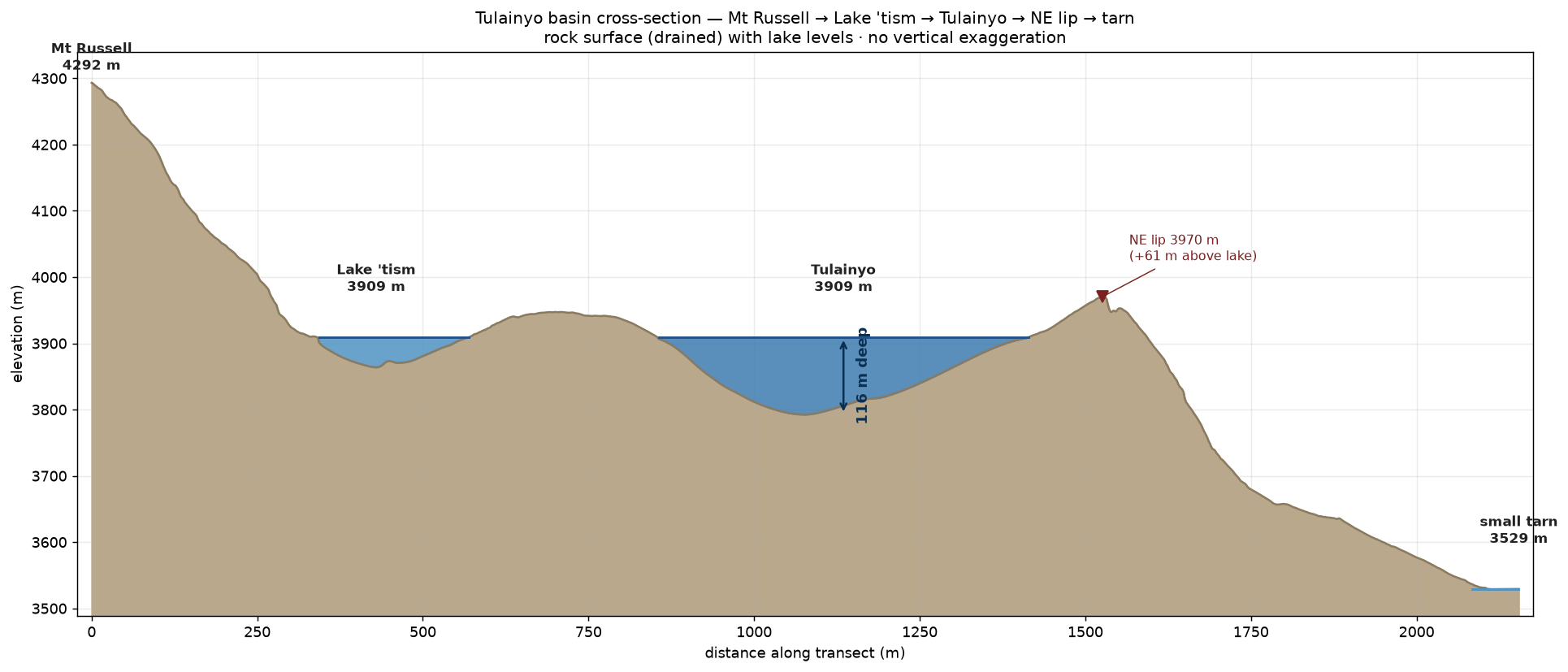
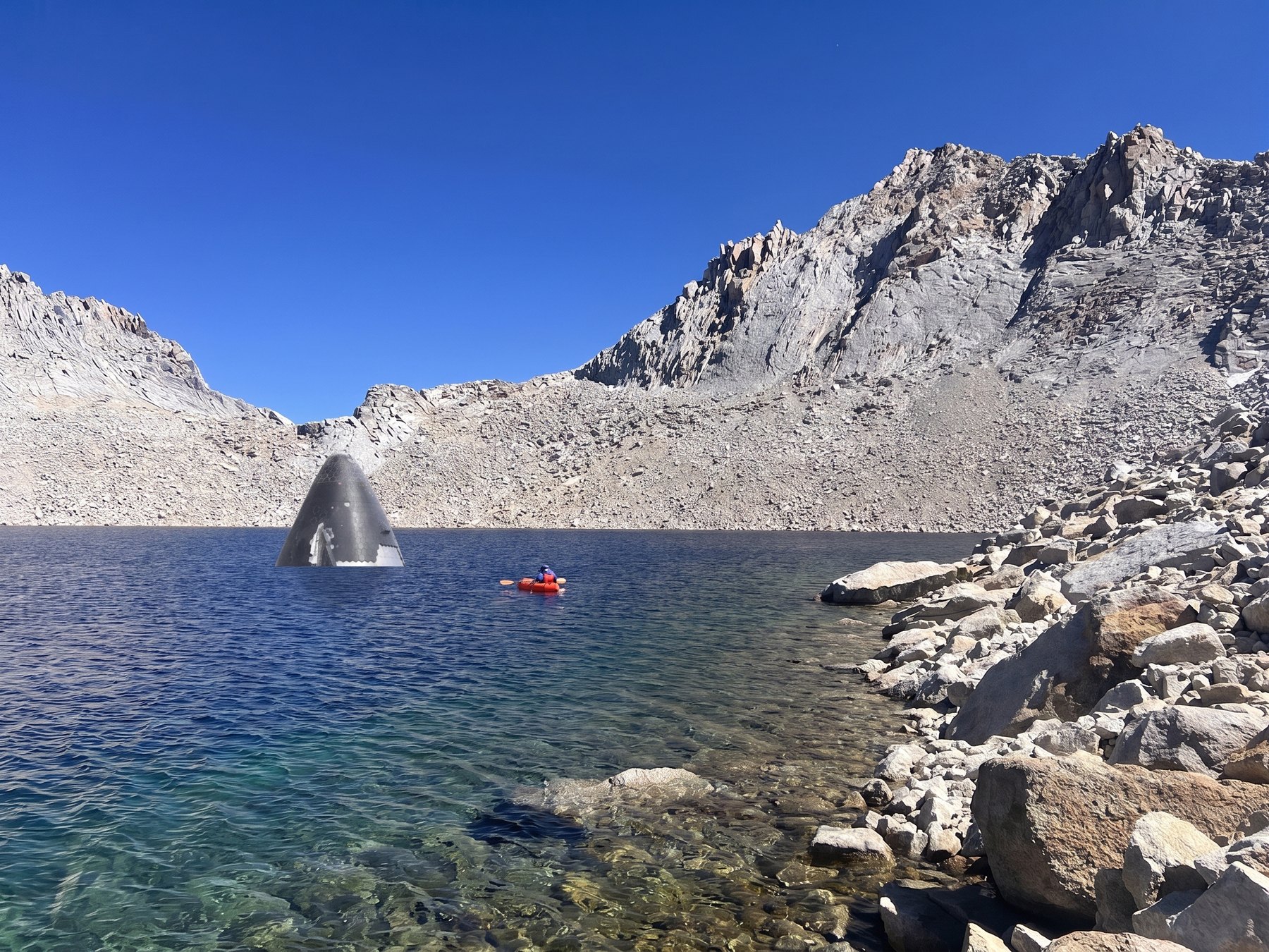
closing the deep hole The buoy loses the bottom past ~100 m, so the very centre of the hole (grey band) is never directly measured — and how you continue the floor across that gap sets the headline depth. Along one E–W transect through the deepest point: the "natural" spline that simply continues the measured wall slopes with continuous curvature reaches 105 m; extending each wall's slope linearly until they cross gives a 118 m V; and anchoring the spline to that V — the reconstruction above — gives 117 m. The walls down to 100 m are hard data; the last ~15 m is a choice of principle. A sedimentation prior would pull the other way: most deep basins slowly fill with flat-lying sediment, which would cap the hole with a level plain nearer 100 m — but the walls plunge straight past that depth with no hint of an infill terrace. The next figure turns that observation into a number.a sediment-conditioned posterior We can turn the last section into an actual probability distribution, starting from a prior of zero sediment and updating it on what the passes that don't bottom out actually show. The straight upper walls, beam-corrected and extrapolated to their crossing, fix the rock basin at a V-apex near 117 m — the depth with no sediment. The measured slope then flattens as it deepens, which would mark a filled, level floor — except that the beam touches the nearest wall as it transitions over the valley, which flattens the apparent floor by itself. Rather than guess how much, we run the forward model over a known deep, straight-walled floor and put it through the same beam correction: the beam alone flattens the apparent floor by ~16 m — more than the ~11 m actually observed. So the observed flattening is entirely accounted for by the beam, leaving essentially no room for sediment. The posterior maximum depth is a median of 117 m with a 90% credible interval of 115–119 m: a nearly-unfilled rock basin right at its sharp apex.the beam flattening, geometrically Why that flattening is geometry, not mud. The sounder's beam is a cone, not a pencil: over the deep V it gets its first echo off the nearest wall inside the footprint, not the true nadir far below, and reports that short slant range as the depth. Sweeping across the hole, the nearest wall sits at nearly the same range the whole way, so the sounder plots a flat floor around −85 m — a full 30 m above the rock apex it never sounds. A perfectly empty V reads as a filled basin; no sediment is required to produce the curve.Lake 'tism Lake 'tism got a space-filling curve (because of course) and showed a maximum depth of 45 m, itself absurdly deep!render · from Tunnabora Peak It emphasizes the continuity of the gradient of the hill above and below the water and the sheer lack of sedimentation filling the basin. The western shore is littered with moraine that is evidently at least 100′ thick (allowing drainage to the west) but how both lakes were excavated to such extreme depths and then not filled with moraine I cannot explain.render · from Mt Carillon The lake is significantly deeper than the lip containing it from draining to the east.transect A cross-section from Mt Russell through both lakes and over the lip, emphasizing the precarity of the eastern edge of the basin preventing their draining to the east. In principle, a severe-enough earthquake could open a crack! No vertical exaggeration.how deep is deep? 256 of the world's and America's biggest and deepest lakes and reservoirs, plotted by surface area against maximum depth (log–log). Tulainyo (upper red star) is barely a third of a square kilometre yet 117 m deep — an outlier far up and to the left of the crowd, deeper than almost any lake remotely its size and, at 117 m, roughly the 25th-deepest natural lake in the United States, out-plunging lakes hundreds of times its area. Its sister tarn Lake 'tism (lower star) is smaller still — 0.05 km² — yet 45 m deep: the same improbable story in miniature. Reservoir depths (▲) are near-dam maxima; a handful of the deepest dams use dam height as a proxy.for scale Image composite showing Falcon 9, Saturn V, and Starship immersed at the deepest point of Tulainyo Lake. This lake is preposterously deep.Data analysis — the detailshow the reconstruction actually works · click to expand
Datums and lake level
The USGS 3DEP 1 m lidar was flown in 2022, a lower-water year; the 2026 survey found the lakes standing ~2.3 m higher, confirmed three independent ways (a commissioned very-high-resolution satellite waterline, the buoy's own GPS-median elevation while afloat, and a barometrically-calibrated hiking track). We adopt Tulainyo 3909.0 m and Lake 'tism 3909.2 m as the 2026 water surface. Every depth is measured downward from that surface; every "floor elevation" is (surface − depth). Because the level varies year to year, a depth is only meaningful paired with its datum — quoting "117 m at the 3909.0 m surface" is unambiguous, "117 m deep" alone is not.
Geolocating each ping
The buoy logs a GPS fix and a CHIRP echogram column (echo strength per 1 cm range cell) per ping at ~10 Hz. The buoy stops fixing GPS below ~81 m depth, so over the deep hole the position is filled from the paddler's Garmin arm-track, aligned to the buoy clock by cross-correlating track shape (the phone clock had drifted >1 hr).
The forward model, and why a naive map is wrong
A sonar reports the range to the nearest bottom point inside its beam cone, and calls it "depth". On a flat bottom that is the true nadir depth. On a steep wall it is not: the wide beam grabs the up-slope edge and reads shallower than the water directly below. The bias grows with slope and beam width (7°/20°/45° were used). We forward-model this explicitly: for a beam of half-angle α over a local slope β, the reported range is d₀·cosβ (for β≤α) or d₀·cosβ/cos(β−α) (for β>α, a wall steeper than the beam), so the true nadir depth is recovered by dividing the reading by that factor. This de-biases the wide-beam readings on the walls — the effect the paddler noticed when switching from 20° to 7° over a shelving margin and watching the apparent depth "increase".
Bayes-optimal, "natural" reconstruction — a 2-D spline by echogram closure
Rather than interpolate the raw soundings (which imprints track-following wiggles and amplifies outliers), the lake floor is a smooth surface — a 40×40 Catmull–Rom B-spline control net, so the depth field is a smooth, low-dimensional function by construction. The control depths are fit so that the simulated leading edge of every ping (nearest in-cone slant range, given the slope-corrected model) matches the observed one, iterated to convergence (a stable, under-relaxed Gauss–Newton). This is the "natural" prior: no reason to assume the gradient changes faster cross-track than along-track, and nothing exciting in the way of underwater structure — the smoothest floor consistent with the data. The B-spline's inherent smoothness replaces ad-hoc curvature penalties; there is a single, physically-motivated slope-smoothing to stop a tight track-loop inflating the beam correction.
Curvature, gradient continuity, and the deep hole
Gradient continuity is imposed everywhere (the second derivative is penalized implicitly by the spline), isotropically — the walls come out steep and smooth, with clean concentric contours, exactly like the drained terrain above the waterline. Over the central ~120 m where the bottom exceeds the buoy's range, no ping constrains the depth; the spline simply continues the measured, de-biased wall slopes inward, which closes the hole at ~110 m on its own and reproduces a hand-built "pointy cone" estimate. Extrapolating the three range-limited crossings' walls to where they cross puts the rock V-apex at ~117 m. To choose between these we start from a prior of zero sediment and let the passes that never bottom out update it: the apparent floor does flatten toward the centre, but that is exactly what a finite sonar beam does — sweeping across the valley it keeps returning off the nearest wall rather than the true nadir. Running the forward model over a known deep, straight-walled floor shows the beam alone flattens the apparent bottom by ~16 m, more than the ~11 m actually observed, so the flattening is fully explained by geometry and leaves no room for real sediment. The resulting sediment-conditioned posterior puts the maximum depth at a median of 117 m (90% credible interval 115–119 m). The near-total absence of sediment is independently consistent with the lake's extreme clarity, its negligible catchment, the complete lack of any observed sediment near the shoreline, and the extreme softness of its water.
Resolution
Spatial cross-validation (holding out whole blocks of soundings) shows the map's effective resolution is set by the paddle-line spacing (~40 m), not by the control-net density — 40×40 is comfortably fine; the smoothing prior carries the rest.
Replication
Raw sonar (per-ping bathymetry + full echogram), the Garmin FITs, lake polygons and levels, the analysis scripts, and the reconstructed grids and maps are available to download and re-run.
Open data. The depth soundings, reconstructed bathymetry and all derived grids and maps are released under CC BY 4.0, and the analysis code under the MIT license — free to use, share, and build on for any purpose, including commercially, as long as you credit Casey Handmer & Edward Jacobs, Tulainyo bathymetry expedition (2026).
Datum for all products: 2026 water surface, Tulainyo 3909.0 m / 'tism 3909.2 m, UTM 11N (EPSG:26911).
Vital statistics
3,909 mlake surface (2026)
117 mTulainyo max depth*
36.3 haTulainyo area
17 Mm³Tulainyo volume
45 mLake 'tism max depth
12,829′highest large lake, Sierra
4.7 kmpaddled
9 °Cwater temperature
*posterior median past the sonar's 100 m range; 90% credible interval 115–119 m. See methods for the datum.
What's next?
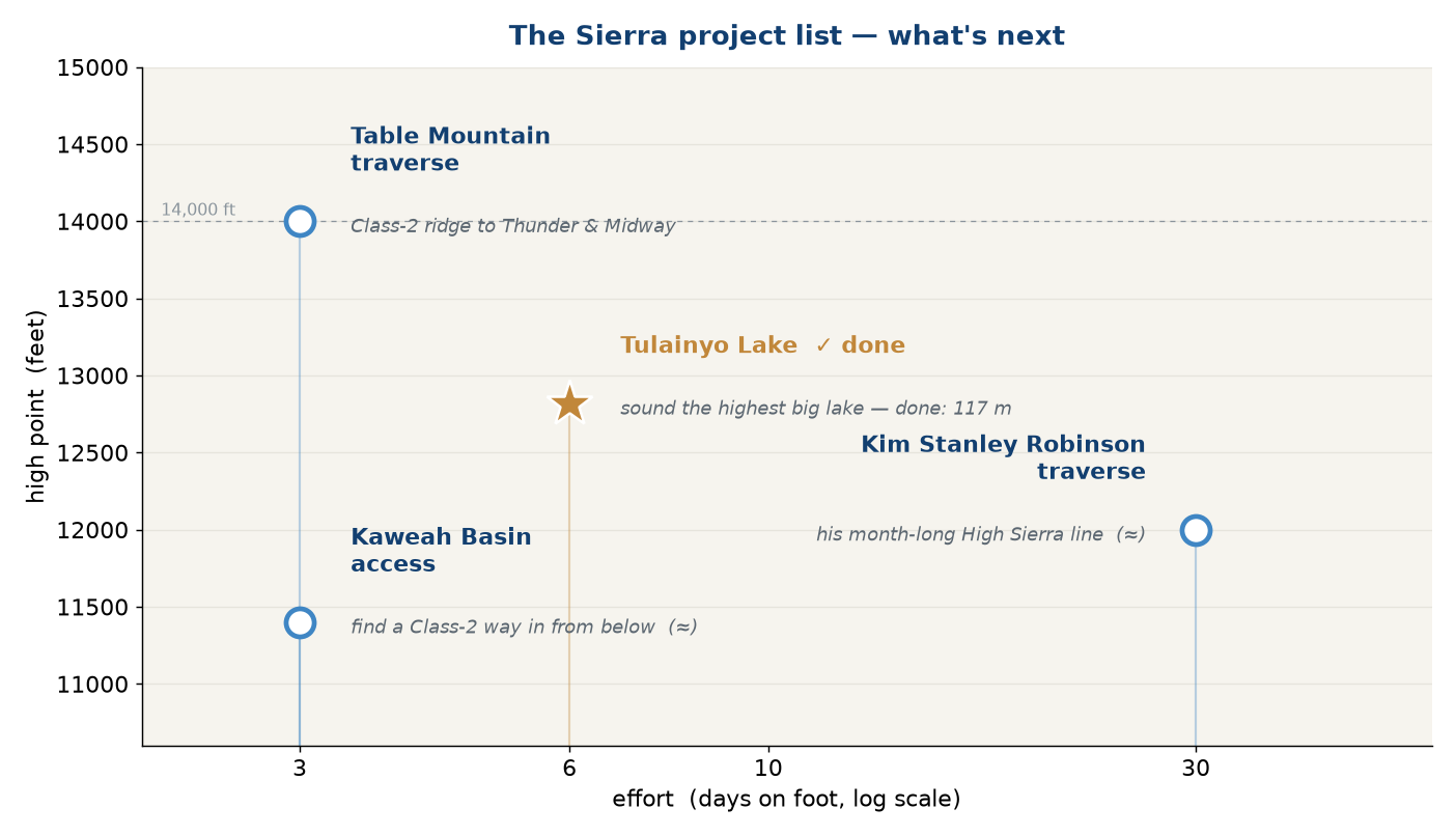
I have a few other projects earmarked for the Sierras. I wouldn't mind giving them a go. And perhaps, taking a crack at the mountains between 13,900′ and 14,000′.
the project list The rest of the list, by high point and rough effort: the Table Mountain Class-2 ridge, a Class-2 way into the Kaweah Basin, and Kim Stanley Robinson's month-long High Sierra traverse. Tulainyo (★) is the one now crossed off.
Table Mountain traverse
drag · pan · zoom
Kaweah Basin
drag · pan · zoom
Stan's High Sierra line
drag · pan · zoom
slope angle
<25° 30 35
40 45 55
>55°· cliff
The three next objectives, draped in slope-angle shading — the view that decides a route. Table Mountain and the Kaweah Basin are built from 1 m USGS lidar, so every couloir, cliff band and class-2 ramp reads at true scale; greens are walkable ground, reds and maroons are the cliffs. The third is Stan's (Kim Stanley Robinson's) month-long High Sierra line on the 1 arc-second DEM, carrying his own route's key points (gold) and waypoint trail (blue) from Enchanted Gorge and Dumbbell Basin down past Mt Sill, Table Mountain and Whitney Pass — it continues north to Tuolumne beyond this frame. Drag to rotate, shift-drag to pan, scroll to zoom.